Coastal Flooding and TS Nicole: Afternoon Update (11/9/22)
Posted at 17:42, Wednesday, November 9, 2022
From Chris Newkirk/Beaufort County EMS:
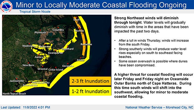
Today’s update from the National Weather Service added coastal flooding charts for the Sound side of the Outer Banks and made minor changes to the timing of projected impacts for Beaufort County. These changes have been highlighted below.
The high pressure system will continue to bring NW winds of 10 to 15 mph until midnight. Frequent gusts of 20 to 30 mph are likely tonight through 7 p.m. Our waterways are expected to be 1-2 feet above normal under these conditions.
The remnants of Tropical System Nicole are expected to move across North Carolina Thursday night into Friday, affecting Beaufort County as follows.
Rain
- Rain chances increase after 1 a.m. Friday and continue through midnight, with ½ to 1 inch now forecast for our region.
- The highest chance of rain is expected to occur between 7 AM and 7 PM Friday, with the heaviest rain expected between 7 AM and 1 PM.
Winds
- Sustained winds between 10 and 20 mph are expected between 7:00 PM Thursday and sunrise this morning. Frequent gusts of 20 to 30 mph are possible between 7 a.m. and midnight Friday.
- Our strongest winds are forecast for Friday from 1:00 PM to 10:00 PM.
- These winds will pass as follows:
- East wind from 8 AM Thursday to 2 AM Friday.
- South wind between 2:00 a.m. and 1:00 p.m. Friday.
- South wind from 1:00 PM Friday to 2:00 AM Saturday.
- South wind between 2 AM and 6 AM Saturday.
- West wind on Saturday from 6 am to 8 pm.
These transitional winds will result in brief periods of water flowing in and out of sensitive waterways throughout our county.
Severe thunderstorms / tornadoes
- Strong to severe thunderstorms, as well as isolated tornadoes, are possible from 7 a.m. to midnight Friday as the bands associated with Nicole move through our area.
See the email below and the attached National Weather Service briefing for more information.
From the National Weather Service – Newport/Morehead City, NC:
No big changes with this update. In this update, we’ve added another coastal flooding graphic to show the new areas affected from Friday into early Saturday as our winds eventually shift from the northeast to the south by Friday.
NWS Morehead City Coastal Flooding & TC Nicole Briefing #6


